Customize Consent Preferences

We use cookies to help you navigate efficiently and perform certain functions. You will find detailed information about all cookies under each consent category below.

The cookies that are categorized as "Necessary" are stored on your browser as they are essential for enabling the basic functionalities of the site. ... 

Always Active

Necessary cookies are required to enable the basic features of this site, such as providing secure log-in or adjusting your consent preferences. These cookies do not store any personally identifiable data.

No cookies to display.

Functional cookies help perform certain functionalities like sharing the content of the website on social media platforms, collecting feedback, and other third-party features.

No cookies to display.

Analytical cookies are used to understand how visitors interact with the website. These cookies help provide information on metrics such as the number of visitors, bounce rate, traffic source, etc.

Performance cookies are used to understand and analyze the key performance indexes of the website which helps in delivering a better user experience for the visitors.

Advertisement cookies are used to provide visitors with customized advertisements based on the pages you visited previously and to analyze the effectiveness of the ad campaigns.

No cookies to display.

Stockghyll Force Waterfall

Wild Swimming
Free!

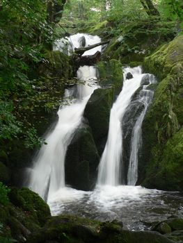
Stockghyll Force, about half a mile east of Ambleside town centre, is a waterfall in a series of cascades totalling 70 feet in height. Stock Ghyll divides into two channels at the top of the waterfall, and then into three, all of which are finally reunited. The falls are surrounded by woodland composed of mixed trees in which beech predominates; in spring many daffodils can be seen at the bottom. There is a railed viewpoint from which the waterfall can be seen. Stockghyll Force can be accessed from Ambleside by taking first Stockghyll Lane and then a well-signposted footpath.

The description for this activity is from Wikipedia.
Marker
Leaflet © OpenStreetMap contributors